


FARMdb – the first result of the international ERASMUS+ project „Fostering Agriculture Rural Development and Land Management” (FARM)
The Department of Business and Rural Development Management of the Faculty of Bioeconomy Development of Agriculture Academy of Vytautas Magnus University is one of the partners at the international ERASMUS+ project „Fostering Agriculture Rural Development and Land Management” (FARM), which is coordinated by the lead partner Harz University of Applied Sciences. Technical University of Cartagena (UPCT; Spain), University of Cyprus (UCY; Cyprus), Association for Internationalization of Education and Science (INTER-EDU; North Macedonia) are actively involved partners. Currently, the first goal of the project has been implemented – the web-based Dashboard/Map called FARMdb has been developed.
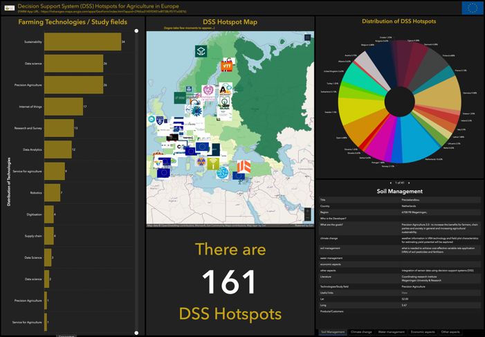
FARMdb (Fostering Agriculture Rural Development and Land Management) is a systematic overview of existing ICT DSS tools in ARD that support crop and livestock, precision farming, climate and quality control and farm management.
The primary function of the FARMdb is designed to provide comprehensive information of DSS tools used for agriculture in the Europe. The FARMdb provides basic information about the decision support systems, developer, and main content of it. The FARMdb is designed for filtering of information based on country or category including soil management, climate change, water management, economic aspects, and others. An important information and data points are effectively presented in a limited space where the user can find the information about the content of the DSS tools, distribution of DSS hotspots and DSS hotspot interactive map in which the data for DSS tools provided together with the link and place where the DSS tool has been developed.
As a tool, the FARMdb is useful for farmers, consultants, and other stakeholders. By using it, they can explore, discover and update the data over time. If information is missing or changing, the FARMdb can be easily modified – the users can actively update the information.
By using the FARMdb, the apps, maps and other items can be shared with the public. Users can access and visualize the data spatially by using the web maps and apps that can be accessed from anywhere at any time. Farmers and other stakeholders can collect, analyse, share the agriculture data with ArcGIS and ease the decision-making process. For example, farmers can check the type and quality of the soil and use this information in their plans for crops cultivation. It helps them to achieve increased, but sustainable production and lead to reduced costs by enabling better management of land resources.
The usability of the FARMdb is it’s reliable and intuitive interface. The FARMdb displays multiple visualizations that can work together on a single screen and allows users like farmers, agricultural consultants, regional planners, policy makers, students etc. visually compare and find relationships between the data across the different natural spaces and administrative territories. It represents a dynamic tool which identifies recent digital decision support systems and helps to develop sustainable and economically sound farm-related future plans dedicated to crop cultivation, fertilization, sophisticated water management strategies etc.
Link to the FARMdb tool here.
Link to the project FARM website here.


